My old 3 terabyte WD external backup drive started making funny noises so I picked up a new 4TB drive today. I have two backup systems where the WD is my primary system image backup while an older Lacie 1TB drive stores a lot of old photos and videos.

Today I moved and organized a lot of stuff off the Lacie onto the WD and as you can see, I've got a lot of space on my hot-rod PC.

  • The C drive is a 256GB SSD holding my Windows 10 OS.

  • The D drive is a 3TB internal holding all my primary data.

  • The F drive is my new 4TB backup drive.

  • The H drive is the old Lacie.

A lot of what's left on H is Steph's old photos and when I'm done organizing, that's all there will be and I'll then disconnect it and store it.

I've come up with a new tool called All Posts which shows every post on the blog, including archives, in alphabetical sequence. Click on a title and it opens the post. I'm also working on some new ones that show all posts from Current, the Begining, Alphabetically and Randomly.

Ever wonder what all of the U.S. zips codes that start with 23 look like on a map? Probably not, but if you would like to try such a thing, click the map below and play with your own criteria...

How about all the zip codes in Texas? Those clusters are Dallas, Austin, San Antonio and Houston. You can zoom down...

Or just browse by City...

...

Steph brought the girls and Dillan over today so I could give them some holiday gifts. We had a fine time, Dillan rocked Fortnite on my PC, the girls had fun, Steph drank her coffee and I fed them some jambalaya. Now I have to get back to my solemn prayers and joyful meditation about the upcoming birthday of my lord and savior. Or, maybe I'll just write code...

Click the photo for more.

I've improved the quality of my zip polygons quite a bit and the before and after image below speaks for itself. I think I've found the right balance of resolution and load time as these things are detailed and responsive. Zip codes with a polygon will be highlighted.

Here's the final result of this project: 40,968 total Zips with 32,220 matching high quality Polygons.

I've built a new database containing all of the Zip Codes in the United States, and developed a tool to analyze them. This is really fun and informative and I've put the query power in your fingers.

Weather Search provides a search box, just like Map Search, where you enter a city name or a zip code and it returns a variety of charts for that location:

  • Hourly Temperature
  • Hourly Wind Speed
  • Hourly Wind Gust
  • Hourly Humidty
  • Hourly Dewpoint
  • Hourly Cloud Cover
  • Daily Maximum Temperature
  • Daily Minimum Temperature
  • Daily Wind Gust
  • Daily Humidity
  • Daily Dewpoint
  • Daily Cloud Cover
  • Daily Moon Phase

You can see the current charts for my area by clicking below:

The urls are also permalinks you can save...

...

It's great when you can have fun doing something, and the results of that effort turn out to be something of value. I whipped up a new tool this morning called Country Flags and it's pretty sweet. Click on a flag and it will display it full size, click on a country name and it will launch the map.

U.S. State Flags:

U.S. State Seals:

Had a busy code day today, adding some new categories and implementing the Embedded Map into everything. I built a JSON database called US Places containing 530 interesting Places and the Map finds them all. I liked the results so much I included them into the Search Map in random order, every time you go there, as Inspiration.

Geography now feeds straight to the map in the form of Countries and the results are damned cool. Oh, and Vegas Casinos also managed to slip in there.

Also, remember that the Info button at the bottom left of the map more than likely will give you the web site of the selected place, if not, at least the Wikipedia. :-)

There's a new tool in the garage, called Map Search. Enter anything you like and I pass it on to the Google API geocoder for the Lat/Lng and then on to my new embedded Google Map. By computing the location in the process I can enable all of the other cool tools at the bottom, which are based on Lat/Lng.

Also note the [Unlock] button at the top. Normally the map is exposed and when you scroll the page it does zoom things to the map, which I consider bad UI. So, I lock it! You can't click on or drag the map until Unlock is clicked. There are so many other ways of looking at the location with the tools below, you may not even need to unlock it. Click the image below and give it a try!

It's almost the middle of December and I haven't seen a single snowflake. Neither has Piper, of course she never goes outside anymore. My, how things have changed...

...

I've been working on some really nice Map code today. I've added U.S. Counties By State, All Cities By State, and tweaked the destination when you select a place. Instead of going to my NeXht app, it goes to a new built-in Google Map, with options.

My goal today was to display polygon outlines around cities and counties. I have the data, and the knowledge to pull it off, but to my surprise Google is doing it for me. Sometimes I really love those guys...

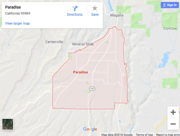
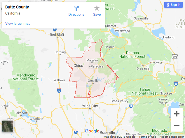
Below is an example map created from the query Paradise, CA and below that is the result of a Butte County, CA query. Considering that I've got more than 20,000 cities in my database, and over 3,000 counties, this little map handles them all. It also works great on National Parks, U.S. State Capitols and Colleges.

The first map will sadly self-destruct shortly...

...

The Box showed up at our place in Idaho one day, and it was talking. I've composed a set of short Flickr videos (they have an imposed time limit on them, Flickr's rule) and you can watch them by clicking the box.

A Flickr video...

...

I applied the one available SSL certificate from my host, to this blog, and the site is now secure. If you look up at your address bar you will see the Lock and the https. The internet is going secure, and I have arrived...

...

Just seeing if I can embed a Vimeo video of Community School kids grabbing treats on my bus.

My daddy used to tell me, the shortest distance between two points was a purple squiggly line. He also told me to never believe anyone that used the phrase my daddy used to tell me. Anyway, my newly refurbished app Route proves he was right on the first point.

I love this thing and I've missed it for a while now, ever since Google started demanding a developers bank account info before coughing up map tiles. I finally gave in, and it's back better than ever. To use it, click on the map to select a starting point, then drag the marker(s) around the map. When you release a marker the route is computed between the two points and presented at the bottom. There's also some cool functions available by clicking either marker.

I'm porting some of my apps over here to the blog. Vue is a great one that I developed as part of the eclipse madness in Teton Valley. It shows a connected split screen of Map and Streetview. Move one, the other follows. I've changed the default position to my neck of the woods but you can create a permalink for any location by zooming the top map out, dragging it around., and then clicking the link icon. Click the image below to try it out...

And of course, a view of Oakland from the City aint bad either...

...

I've created a new tool, available under Tools, called Geography. It presents every country in the world and shows a map of the country you select. Simple...

Update: The apps just keep coming... Two new ones are now up there: Largest Cities shows the top 99 largest cities in the U.S. and State Capitols gives you a birds-eye view of all fifty state capitols.

More: Colleges shows the top U.S. colleges and National Parks gives you links to all of them.

Oh, and of course, all of my favorite Places!

Whew, busy day...

...

I took the photo, did the art, it's original...

...

Tasty cupcakes and great spaghetti were featured at Steph's birthday gathering, of which I was pleased to attend. Click the cakes for more...

...

I've whipped up a sweet little Slideshow app (chose a Set and select SlideShow at the top) and discovered some old favorites:

Stephs mom Betty:

Paper tited Amy: (run the Slideshow)

The hundred year old man: